We’ve been asked about means of navigation and method of planning many times during the past few weeks, so we thought it’s time to sum it up here. Maybe it will make life easier for other tourers.
Navigation
We bought loads of maps before starting our trip, but soon realised that they are dead weight, as we are not using any of them.
We only navigate with our smartphones.
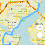
On these the GPS signal always shows our location and we use MAPS.ME, a free application for iPhone and Android, for mapping.
In the app you can download maps by country, with or without the navigation.
Pros
- small, fast and reliable
- easy to check distances
- you can pin/star places
- includes services, institutions, places of interests
- you can search for services nearby, e.g.: ATM, water, petrol stations
- you can set your destination with coordinates
- you can import KML/KMZ files
Cons
- can’t plan across borders
- you can only plan route with car, hence it will always try to take you onto a motorway
- you can only plan route from your current location
- you can only search for streets (not house numbers), and it can’t always find it
- sometimes it surprises us with dirt-roads
- it took us twice onto non-existing roads
All in all, we love it and highly recommend it. The car routing is a bit annoying, but it’s easy to get around if you set destinations for smaller waypoints you’d prefer to go through instead of the main roads / motorway.
Just in case, if we need to go to a certain address, we like to double-check it on Google Maps (if we have access to the Internet). It’s also worth to take a look at very small roads on streetview, if you can.
You can download MAPS.ME from here.
I previously used iGO to navigate on the bike, and it was great. You can plan for bicycle or pedestrian with it, but it’s expensive and takes up a lot of space, so if you don’t already have it, I think MAPS.ME is a better choice.
Route planning
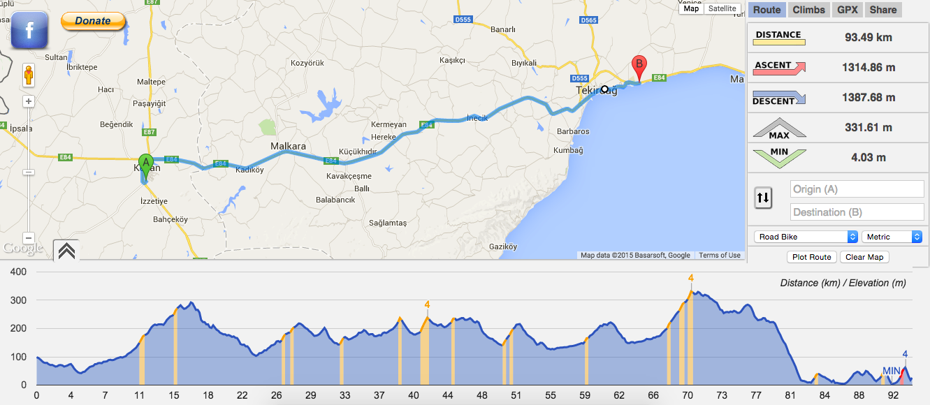
We plan our daily and weekly distances on cycleroute.org.
This is a web application that shows you the elevation on the road. It’s invaluable for cycle tourers!
The elevation map is colour-coded: the blue climbs are easily doable, you barely notice it, the yellow ones are definitely noticeable, and red ones are really steep climbs that will leave you panting at the top (at least if you have 40+ kg bikes to get up there, like we do).
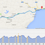
CycleRoute is completely free, a project of a german developer. If you start using it, we urge you to support his work and donate some money in support to his very useful work. We did so, as well.
So, we rely on CycleRoute when we plan our days and weeks:
Right now our easy days are 80-90 km long with 600-800 metres of ascent, but we can do a 110 km / 1300 metres ascent with no problem. It only means that we have less time to waste on sipping coffee or çay by the road, talking to strangers.
We plan our weeks with the elevation in mind as well. After Istanbul, our route in Turkey is expected to be hilly, so we now plan 400-450 km long weeks, which we’ll complete in 5-6 days, then we’ll have 1-2 days off the bikes to rest our legs and do some sightseeing.
I’ve just been recommended another app on a cycle touring forum: OsmAnd+.
I’ve bought it and I’ll be testing it in the upcoming weeks. We’ll be back with a review later.
+1 for OsmAnd. I’ve found v2 to be an improvement over version 1.x but you’ll have to install that from nightly build. I also like http://www.plotaroute.com/ for route planning. I’ve found it to be the most complete function wise and the GPX it generates plays well with the routing function in OsmAnd. I also use an external GPS connected over Bluetooth to the smartphone… but that’s another story.
Anyway, great blog, enjoy reading it.